


The Bottesford Landscape - then and now
The view from the church tower, 1950 and 2014
By Neil Fortey and Michael Bradshaw
Sunday, 24th Aug 2014, provided a welcome opportunity to climb the winding stair up to the walkway behind the parapet on the tower of St Mary’s and photograph the vista in all directions (the cream tea was excellent too). It was also an opportunity for Michael Bradshaw, once a resident of Bottesford but for many years settled in the sunny climes of Adelaide, to do a bit of arm twisting and have pictures taken to compare with photos his dad, Police Sergeant Arthur Bradshaw, took from the tower back around 1950. The idea was to see how the village has changed over the intervening 64 or so years. There have been great changes, as you would expect. Many building familiar to us today have been added, but one of the most fascinating aspects of these pictures is the number of things we can see in them that have disappeared – fields, hedgerows, buildings, the gas-works and the steam trains. We glimpse a lost world, that of the village as it was during the years after the Second World War. Indeed, there can be little that had changed since before the war, though building of new housing had already begun, for instance in the council-built homes around The Square, constructed by Bill Roberts’ firm during the late 1940s. Sergeant Bradshaw on duty at the Bottesford Village Fete
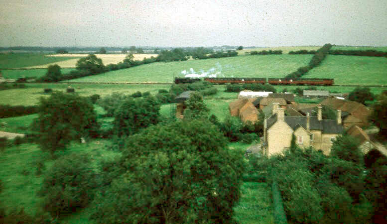
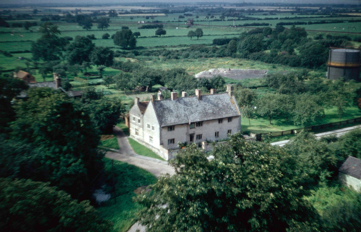
Looking north in 1956. This picture shows a steam-hauled passenger train traveling westwards bound for Nottingham, beyond the house and outbuildings of Beckingthorpe Farm, which was still very much an active farm owned by Mr Philip Marsh.
Michael Bradshaw
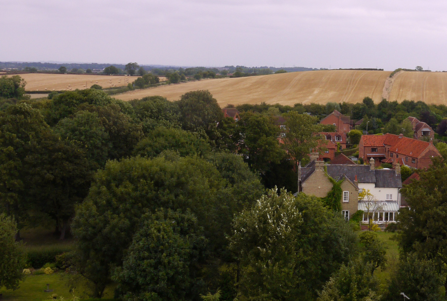
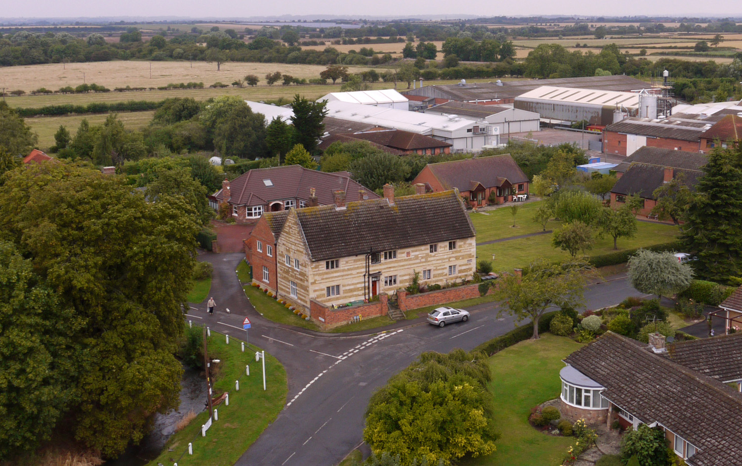
Looking northwards from the tower in 2014. This shows the same view, but the railway is largely hidden by the trees that have grown. Beckingthorpe House is clear, but there is now housing on the old paddocks as well as rebuilding of buildings of the old farmyard.
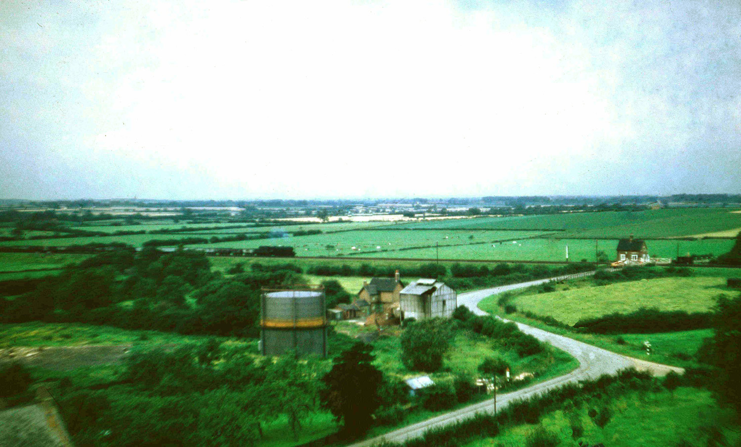
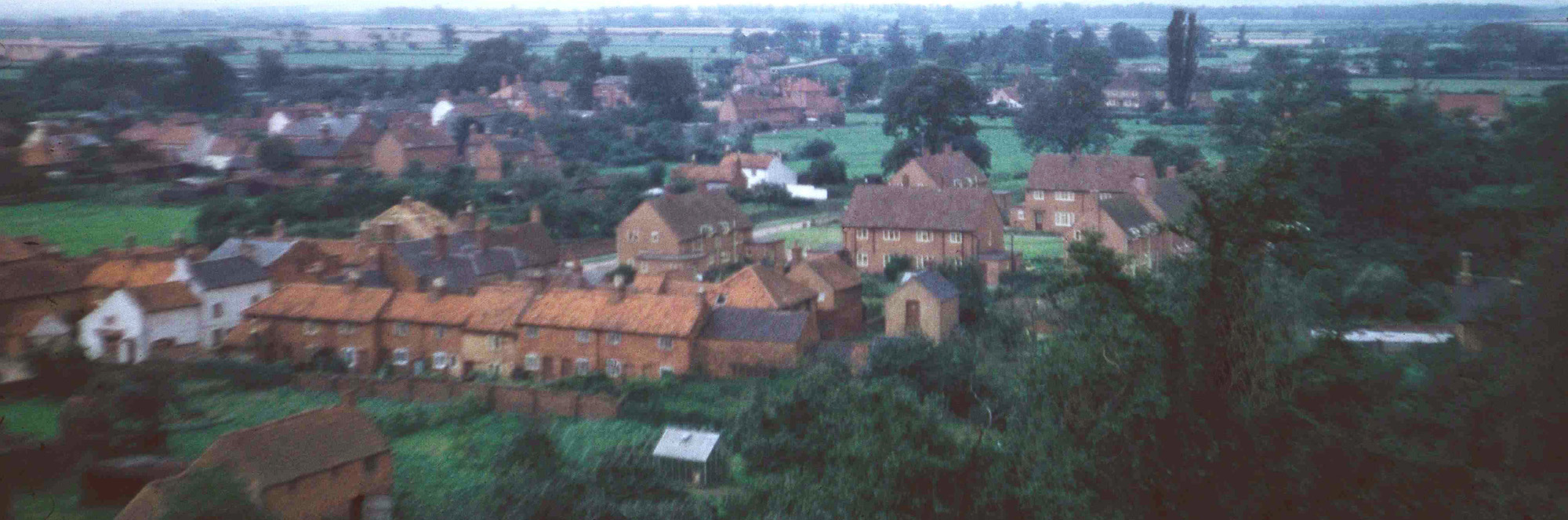
Looking north west from the tower in 1956. In this view, looking northwest from the church tower, we see Normanton Lane bending left at the junction with Station Road and then right as it approaches the railway crossing. The crossing gates are closed, and there is a yellow vehicle waiting for an eastbound freight train, approaching from the left, to pass the crossing and its attendant crossing-keeper's house. To the left of the junction with Station Road is the single gasometer of the Bottesford Gas Works, which had for many years supplied coal-gas for street lighting and domestic use. To the right of the gasometer is the box-like structure of the furnace house, and behind this is the brick office building that is now a day-nursery. The two fields immediately to the left of the gas works used to be the site of the Bottesford brickworks operated by the Challands family. These are now the site of the Normanton Lane Industrial Estate and Community Recycling Centre.
Michael Bradshaw
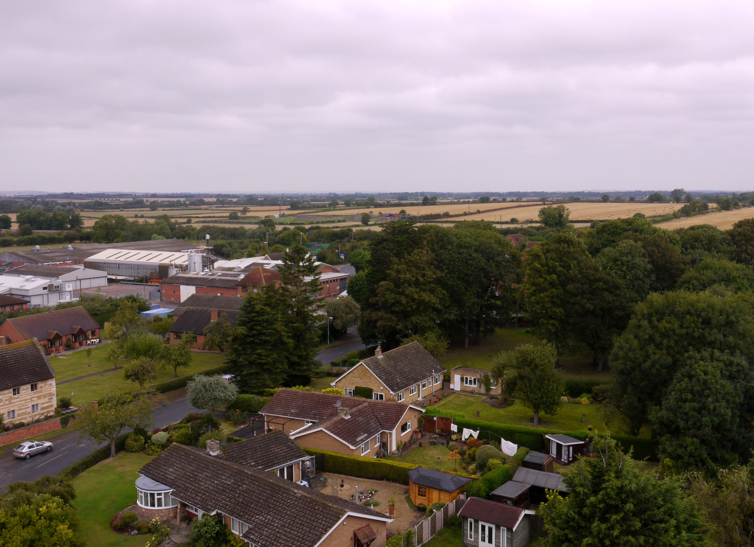
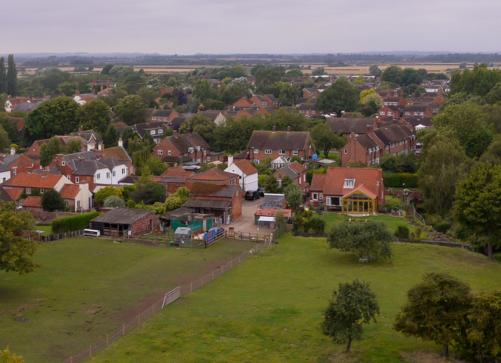
Looking northwest in 2014 Believe it or not, this is essentially the same view, but seen as it is today. Many of the features visible in the 1950s are now hidden by the trees that have grown up, but the cluster of light industry building of the Normanton Lane Industrial Estate is clearly laid out. In the foreground are some of the houses built during the expansion of the village since the end of the war.
The Rutland Hospital c.1956. This view clearly displays the roofs of the Rutland Hospital, an almshouse for elderly village men that was first established in 1591 by Countess Elizabeth. To its left is a blue patch where the sky is reflected by the River Devon. To the right of the almshouse is an orchard, one of many that there used to be in Bottesford. Further right is the gasometer of the old gas works, and behind it the site of the old brick pit, still with a large heep of barren ground. Open fields stretch away to the WNW, and the embankment of the Grantham-Nottingham railway crosses from right to left. We can also pick out a locomotive and tender seemingly traveling northwards on the old N-S railway that ran from Melton to Newark, passing beneath the Nottingham line (the bridge is just visible).
Michael Bradshaw
Rutland Hospital 2014, and Normanton Lane industrial estate This modern view again shows the Rutland Hospital and the River Devon, but the orchard has been replaced by an open lawn, and there are modern houses at the back of the Hospital grounds. Behind these is Normanton Lane Industrial Estate, while beyond the open fields still stretch away to the horizon.
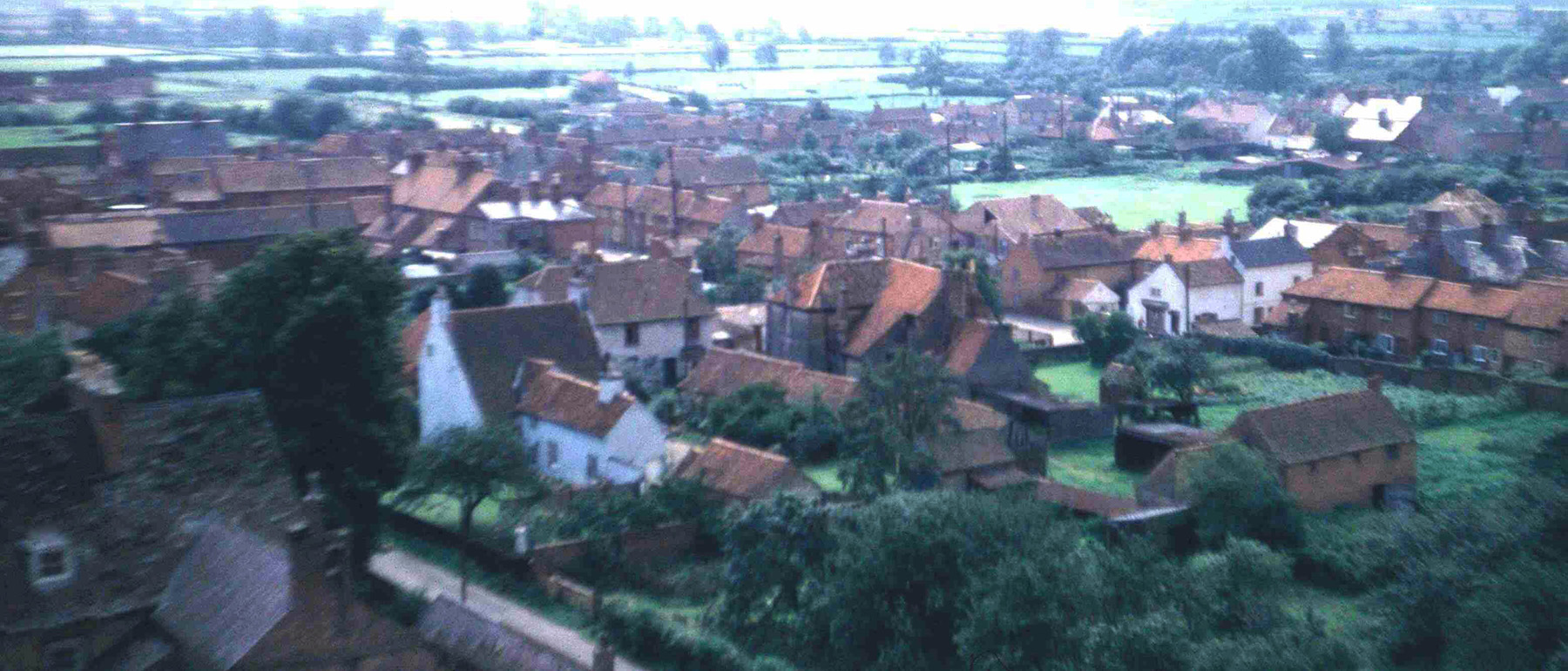
Looking towards the west end of the village, c.1956. This view is looking just south of west, towards the western part of Bottesford. To the left we can trace the houses of Chapel Street and Albert Street, with High Street in the distance. There are still open fields where the Walford Close and Spire View estates are today. The conspicuous terrace of cottages running into the centre of the view is the old Retford's Row, a close that stood behind Chapel Street from which it was reached via a covered archway that is still there. Behind Retford's Row stand the new houses of The Square, and behind them we can see the open field on the western side of Albert Street, at the rear of which runs Pinfold Lane. This view reminds us how much open space there used to be right in the middle of Bottesford.
Michael Bradshaw
The same view today. Much the same view, but Retford's Row has completely gone and most of the open fields have been infilled by modern housing. The open ground at the front of the view is part of Roberts' Paddock, once an area of orchards, and on the right is the bungalow built by Mr Bill Roberts, Bottesford's remarkable entrepreneur whose building firm's yard and offices stood on the corner of High Street and Barkestone Lane.
The view towards Queen Street, c.1956 .In this view we are looking more or less to the southwest. The prominent white house still stands (and is still white) at the corner of Rectory Lane and Chapel Street, but the large farmhouse to its right, the former 'Singleton's Farm' on Chapel Street, was demolished in the 1960s. Beyond this lies Queen Street, where the roofs of the old Police Station and of the malthouse are clearly seen. Beyond Queen Street is the open field of Parnham's Farm, now the site of the Walford Close estate. High Street runs across to its rear, and then nothing but open fields where today are the estates and schools built to either side of Barkestone Lane.
Michael Bradshaw
Looking towards Queen Street,today, 2014. In this contemporary view the layout is much harder to make out largely due to the proliferation of modern housing that has developed in Bottesford.
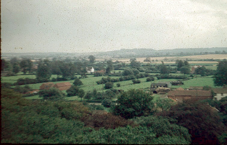
The vista southwards towards Belvoir Castle, c.1956. This picture looks approximately southwards, with Belvoir Castle tiny in the distance upon its hilltop belvedere. On the right are Daybell's Barn and Farmhouse, and the white building further away is a house on Manor Road, Easthorpe, but the scene is dominated by the serene expanse of open farmland that extends as far as the eye can see.
Michael Bradshaw
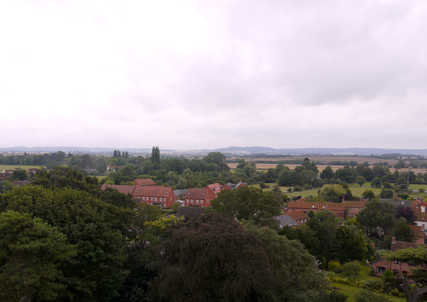
The view towards the castle today, 2014. In this contemporary picture the most conspicuous feature is the small estate of houses built only recently on the southern side of Grantham Road, though Daybell's Barn and Farmhouse are also clearly visible. Fields still extend the the horizon, and Belvoir Castle stands proud upon its hilltop. Easthorpe nestles hidden among its trees, and the congestion of the A52 bypass is mercifully hard to spot.
Time period
This page was added on 31/08/2014.


Comments about this page
Enjoyed reading about it very much, and seeing all the changes that have happened since I came to the village in the 1950s.
Hello Jean, glad you enjoyed it. I’d have preferred to be up the tower when there are less leaves on the trees, but you have to grab the opportunity when it is made available (not to mention the excellent cream scones for those waiting to go up). As well as the scones, there was a short talk by the bellringers on the history of the bells, with a demo of ringing, plus the chance to glance into the ringing chamber itself while ascending the steep upper part of the stairs. A very enjoyable occasion. Neil
This is remarkable. Amazing to see the changes, and nostalgic to see the old steam trains, and to be reminded of the joys of ‘train-spotting’, and it only seems like yesterday. Pity the orchards have all gone. Many thanks to Neil and Michael for a terrific presentation. Sergeant Bradshaw is fondly remembered too.
Yes, very good photographs of the old village which I spend countless hours stitching together and restoring through photoshop. The seventh and ninth images I tried to stitch together using advanced software for a panoramic view of old Bottesford but it wouldnt “have it” in the end. I must let you have the finished view toward Belvoir which is now much better than the one featured. The year these were taken was summer 1956 and not 1950 as mentioned. Mind you Michael Bradshaw wouldn’t have known that because he didn’t complete the work, but has taken credit for it.
Hi Richard, thanks for the comments you are posting on the site. There’s nothing like first hand knowledge of a place, and I shall correct the photo captions to 1956. All the best, Neil
Add a comment about this page