Geology of the Bottesford Area
Exploring the Vale of Belvoir
By Neil Fortey


Rocks and minerals play a vital part in very many aspects of day to day life. “If you can’t grow it, you have to dig it out of the ground”, as someone once said. We are totally dependent on metals, minerals, oil and groundwater. Underlying rocks are also important in creating productive soils, and therefore to the success of farming.
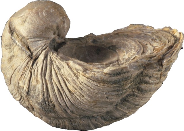
Despite the lack of bare rock crags, bedrock is never far beneath our feet, and fossils appear where the clay soils have been ploughed or excavated. Fossilised shells of the exctinct oyster known as Gryphaea, or popularly as the “Devil’s Toenail”, are easy to find in the country around Bottesford, and delight children when the come across them on footpaths and in gardens.
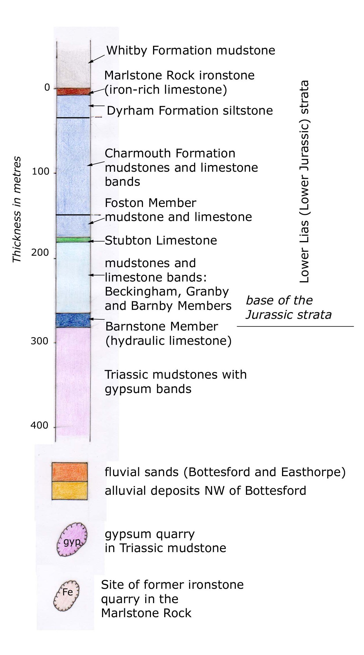
The mudstones and limestone of the Vale of Belvoir around Bottesford and Muston belong to the oldest part of the Jurassic Period. West of the low escarpment that stretches from Langar round to Staunton are older, Triassic mudstones with beds of gypsum. These rocks were formed as layers of sediment on ancient sea beds. The strata tilt gently southeastwards, so that the outcrop becomes progressively younger towards the Chalk of the Lincolnshire Wolds. This is country of subdued relief, with many flat areas and fens, in which bedrocks are rarely exposed. Deep beneath lie deposits of coal whose mining was proposed in the 1980s. Oil and gas have also been extracted on a small scale.
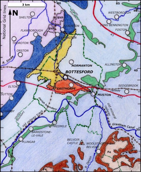
The geological map shows the rock formations in the Bottesford area. Each formation is shown as a band of different colour, showing where its outcrop runs across the countryside. It is based upon the geological maps mentioned, with the permission of the British Geological Survey. The key sets out the names of the formations and the age-sequence in which they occur.
Detailed information can be found in British Geological Survey maps Nottingham (E126), Grantham (E127), Melton Mowbray (E142) and Bourne (E143). These and books about geology can be purchased from: The British Geological Survey, Kingsley Dunham Centre, Keyworth, Nottingham BG12 5GG, or online at www.bgs.ac.uk . These are immensely, bewilderingly detailed, technically precise publications. Looking at the gentle fields of the area you might wonder how the experts can know what lies beneath us in so much detail. It’s a good question, but not one for this brief summary.
Another source is “The Geology of the East Midlands”, Geologists’s Association Guide No.63 (2003), which includes an excellent if somewhat muddy walk across the “Liassic of the Vale of Belvoir” described by Alan Brandon, which starts at Sutton in the Vale and follows public footpaths SE to Barkestone and then on to Belvoir Castle.
The Bottesford Community Heritage Project is grateful for the advice and assistance freely given by John Carney, Graham Lott, Caroline Adkins and Jim Rayner of the British Geological Survey, and by Glynda Easterbrook of the Open University.


Comments about this page
Hi Neil
I recall that you pointed out the correlation of the alignment of Vale of Belvoir villages with the the Stubton Limestones (Plungar, Barkestone, Redmile, Allington etc). Quite remarkable to see in the map the impact of hidden geology on the settlement pattern. Are the Churches built from this limestone? Dave
The main stones used in local churches are (1) a red-orange iron rich limestone, (2) a flaky grey limestone and (3) a grey hard limestone. No. (1) is generally thought to be from the Marlstone Rock which forms the top of the escarpment of Belvoir Castle – a good example is the masonry of Eastwell parish church. No. (2) is more problematic in that it was probably from small local quarries which might have been in Stubton Limestone but might also have been in some of the other limestone bands that occur in the Lias. This is a soft, poor quality stone and probably was not used if (1) was available. Stone no. (3) is the high quality stone (ashlar) used in windows and the corners of churches (quoins) and probably came from the quarries around Ancaster. So the answer to your question is a qualified ‘yes’, subject to the uncertainty of knowing where the local stone pits were.
Neil
The stones used in the prominent buildings, including the churches, would have been very obvious to the team mapping the area.
Allan Brandon, not Alan Brandon
I found an interesting stone here in the vale last week. It seems to have iron in it?
Unfortunately it wont let me post it on this comment box.
I’m happy to email them if anyone is interested.
Hello Julie, I am not sure what the problem is, though it is true that the comments box does not take photos. You could email a picture or other details to [email protected], if that helps. As for the iron, that is certainly a feature of local geology. The escarpment of Belvoir Castle contains iron-rich stone, as seen in several old buildings and walls around Bottesford and the Vale, and there are also loose blocks to be seen here and there. There was iron-stone mining around Harston and further west, mostly in the late 19th and early 20th centuries. So you are right on the ball! Best wishes, Neil
Add a comment about this page